904.504.5744
|
904.504.5744
|
geoMobiliti & GIS
|
|
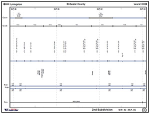
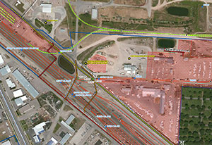
Mapping the wayGIS SolutionsClients need a GIS professional who understands their business practices and has the expertise necessary to develop GIS tools tailored to their unique needs. geoMobiliti is in the solutions business. We develop programs that generate the best results for each client, using the following key steps along the way: Needs Assessment - Help identify GIS scope and viability by evaluating overall business practices, proposed needs and IT requirements. System Design - Engineer GIS systems to meet the specific needs of each client Technical Support - Provide GIS support, software expertise and extensive railroad knowledge to help meet your short and long term goals and objectives. Education - Establish rail-related training to help clients apply GIS to specific work flows. Overlays/Geo-referenced Valuation Maps - Overlay field collected data on imagery or geo-referenced valuation maps for assets management and to expose opportunities. Web Based Mapping and Enterprise Solutions - Extend web-based mapping and enterprise solutions through industry partners such as ESRI’s ArcGIS Server® to publish maps. Railroad GIS DevelopmentgeoMobiliti has close to two decades of experience in the development of railroad Geographic Information Systems. The GIS can be specific to the real estate department or span several departments in an enterprise GIS. Features can be integrated from available data within each department or collected as new feature classes. GIS based Track ChartsgeoMobiliti has developed an efficient and inexpensive way to create track charts based on GIS layers. Once engineering data is integrated in the GIS, we can create a custom designed Track Chart for you at a fraction of the cost other companies offer. And we offer free quarterly updates for 2 years of the existing sheets. ArcGIS ServergeoMobiliti is dedicated to delivering superb services and applications. We offer ArcGIS server as well as ArcGIS Server using the FLEX API. GIS Safety and SecuritySafety and security have taken a higher priority in recent years. Railroad managers have developed Geographic Information Systems with the capability to identify in great detail non-railroad assets in the communities through which they travel. When called on to deal with crashes, spills, or other unusual events, railroad officials can use a GIS for immediate access to local data such as streets, at-grade crossings, and rescue contact information. Mobile GISThe greatest expenditure in developing a GIS is data collection. As companies attempt to find ways to do more with less, geoMobiliti has proven to be an asset in developing efficient, cost-effective field data collection and data mining techniques. Mobile GIS helps field crews capture data quickly with acceptable accuracy while eliminating the unwieldy process of making annotations on paper maps. Using a laptop or handheld device that makes use of GPS technology, field crews can enter data directly into a mobile GIS database, removing the need to print paper maps and take them into the field. geoMobiliti can create custom tools for mobile data collection and inventory to meet the client’s needs. Through collaborative efforts, we can team up to select a device best suited for each data collection effort. We can then follow up with an interactive mobile GIS/GPS training session that matches the custom application. |
GIS & Information Management We develop, manage and deliver a full range of spatial technology as identified by the client's needs.
|
Track Charts
GIS Overlays
|
|