904.504.5744
|
904.504.5744
|
geoMobiliti Services
|
|
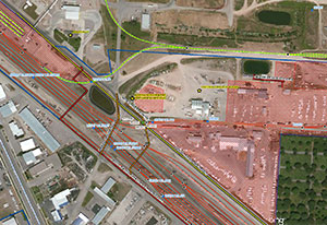
Working smarter, for you.Improving the mobility of today’s goods and managing assets can be a great challenge. Maintaining existing equipment as well as planning for new installations can be considered one of the most time consuming and costly parts of for business operations. Using a Geographic Information System (GIS) can help minimize operational and maintenance costs, identify reoccurring deficiencies and enhance safety. Real Estate Related ServicesgeoMobiliti has over 15 years of railroad real estate experience. This is the experience that you can utilize when it comes to improving the efficiency of real estate and licensed agreement management. We can review existing agreements to confirm that they are a fair market value, permit any new occupancy application and identify and license all utility and land encroachments. We can also help by scanning and indexing your legal documents, maps, or project related correspondence. Additionally, we can identify and market your surplus property. Field AuditWe have developed a complex and effective process to collect data about wayside assets, utilities and land occupancies on and along the rail corridor. This information can be used to compare to office maintained data to expose inconsistencies, ultimately creating a data repository to all railroad personnel to utilize with confidence. The information collected during the field audit will be the foundation of a GIS. Data Analysis and IntegrationgeoMobiliti has vast experience in analyzing data from any number of sources and compiling them into a single data source. Different departments collect and maintain data in their own special way. This may include Microsoft Access databases, spreadsheets, text files, or existing server based databases like Oracle, MySQL Server and Microsoft SQL server. Regardless of the format, we are confident that we can assimilate your data into one tidy package. Server Based GIS DeploymentWeb-based mapping enables GIS administrators to develop a centralized database with an enterprise reach that is accessible to anyone with a web browser. geoMobiliti can develop a web-based mapping system that provides the power of GIS in an easy-to-use and cost-effective design. To distribute maps across a wide user group, web-based GIS is a powerful tool. Many geoMobiliti clients have found that GIS is a tool that should be in the hands of everyone from managers to administrative staff and field crews. geoMobiliti can develop the appropriate GIS design for a workgroup, department, or entire corporation by conducting a thorough GIS needs assessment. |
GIS Overlays
Relational Database Design Staying in the forefront of software and technology so you remain an industry leader.
|